


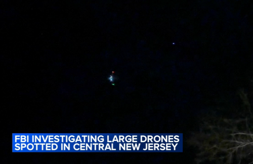
In mid-November 2024, Morris County, New Jersey filed the first report. Multiple large drones, flying in patterns near the Raritan River. Within days, sightings spread statewide - over Picatinny Arsenal, Trump's Bedminster golf course, reservoirs, towns. The FBI fielded 5,000+ tips. The FAA imposed flight restrictions backed by "deadly force" warnings. Local officials demanded federal action.
Then in January 2025, the White House confirmed what many suspected: many sightings were FAA-authorized research drones, hobbyists, and misidentified aircraft. But dozens of incidents remain unexplained. The panic was partly suburban pattern-matching - and partly genuine uncertainty about what's overhead.
Those six weeks made millions of Americans realize they needed an answer to a question that never mattered before: who's flying over my house?
That question isn't going away. The infrastructure exists to answer it. But nobody's packaged it for normal people yet.
The timing is structural, not viral
Three shifts locked into place in 2024.
Remote ID became mandatory - drones now broadcast their "license plate"
As of March 16, 2024, the FAA requires registered drones to broadcast Remote ID - essentially a digital license plate transmitted via Bluetooth and WiFi that includes the drone's location, altitude, velocity, and operator control station. The rule covers all drones over 250 grams used for any purpose beyond pure recreation.
Every compliant drone continuously broadcasts an identifier that anyone with a receiver can pick up. The FAA delayed enforcement twice due to supply chain issues with broadcast modules, but the deadline passed. It's law now.
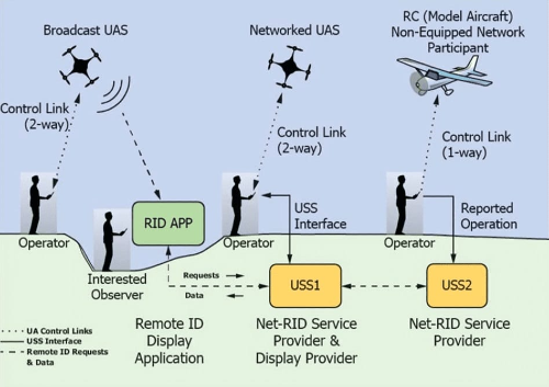
The broadcast standard runs on existing wireless protocols. Any device with Bluetooth or WiFi can theoretically receive these signals. Open-source implementations already exist for Android receivers.
Live broadcast data is in the air right now, every time a registered drone flies.
Drones are moving from hobby to infrastructure - fast
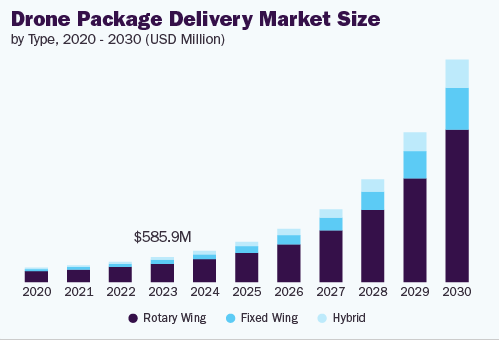
The drone delivery market hit $693 million in 2024 and is projected to reach $4.7 billion by 2030, growing at 37% annually. Wing Aviation (Alphabet) has completed over 400,000 deliveries. Zipline passed 1 million autonomous deliveries across four continents. Walmart rolled out drone delivery across 100 stores in partnership with Wing and Zipline, covering 2 million customers in Dallas-Fort Worth alone.
The FAA approved Beyond Visual Line of Sight operations for multiple operators in 2024, including Zipline for medical and retail deliveries. The agency expects definitive BVLOS rules by December 2025, which would remove the largest regulatory barrier to scaled commercial operations.
Pilot programs have evolved into operational infrastructure expanding into residential airspace. Even when specific programs pause or pivot, the direction is clear: more autonomous aircraft overhead, permanently.
"Counter-drone" is exploding - but the consumer layer is missing
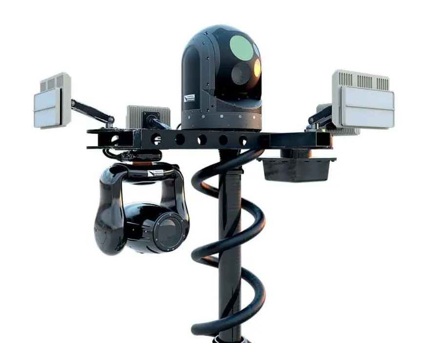
The counter-drone market reached $2.45 billion in 2024 and is projected to hit $12.2 billion by 2030. Detection systems alone grew to $694 million in 2024, expanding toward $8.4 billion by 2034.
Look at who's buying: military and defense captured 61.8% of the market in 2024. The next largest segments are airports, critical infrastructure, and government facilities. The technology comes from defense contractors - Lockheed Martin, Raytheon, Thales, SAAB - selling systems that cost six figures and require specialized installation.
The residential and small business layer doesn't exist. A homeowner, HOA, school, or small facility can't deploy counter-drone detection without writing a check that makes no economic sense.
The missing layer: consumer-packaged airspace monitoring
Remote ID receivers already exist - Dronetag RIDER and DroneScout sell portable units to police departments and security teams for $1,500-3,000. They work. They detect compliant drones at range. They stream data into professional monitoring systems.
What doesn't exist: consumer UX, consumer pricing, neighborhood-scale shared logging, installer distribution, or law-enforcement-friendly reporting for homeowners and HOAs.
The opportunity isn't inventing the sensor. It's wrapping existing technology in a product normal people can buy, install, and actually use - then building the network layer that makes the data valuable.
The opportunity: "TruePeopleSearch for your airspace"
SkyFence is an always-on airspace log for homes and neighborhoods:
Unlock the Vault.
Join founders who spot opportunities ahead of the crowd. Actionable insights. Zero fluff.
“Intelligent, bold, minus the pretense.”
“Like discovering the cheat codes of the startup world.”
“SH is off-Broadway for founders — weird, sharp, and ahead of the curve.”


